


Capturing the Real-world turn it into digital
OpenCities Planner
Cloud-based City-scale Planning and Visualization Service for Digital Twin

ซอฟต์แวร์แบบ cloud-based อันทรงพลังสำหรับการวางแผนและการออกแบบเพื่อพัฒนาเมือง และการดำเนินงานด้านโครงสร้างพื้นฐาน (Infrastructure Projects) สู่การเป็นเมืองอัจฉริยะ (Smart City) ผสมผสานเทคโนโลยี Digital Twins
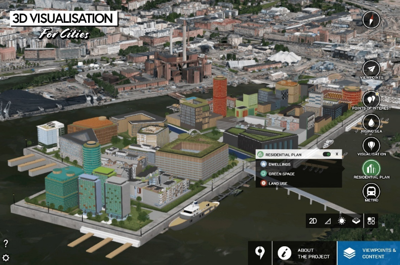
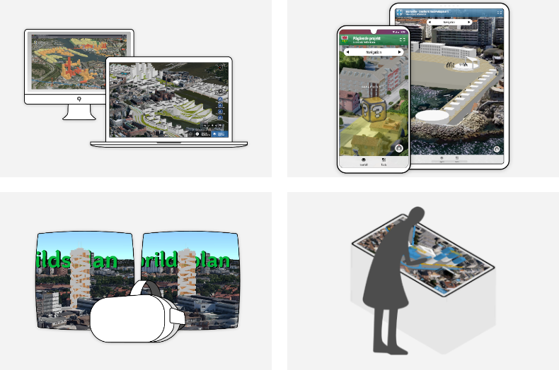
OpenCities Planner ทำหน้าที่เป็นศูนย์กลางสำหรับรวบรวมข้อมูลเพื่อจัดทำ Digital Map โดยรองรับการทำงานร่วมกับข้อมูลหลากหลายประเภท ทั้งข้อมูลรูปแบบ 2D (Shape Files, PNG, Satellite imagery, AutoCAD และเอกสารต่างๆที่เกี่ยวข้องกับการดำเนินงาน เป็นต้น), 3D (BIM, Reality Meshes, 3DStudio, Digital Terrain Model และ CityGML เป็นต้น) ข้อมูลด้าน GIS และเชื่อมโยงข้อมูลจาก Website ต่างๆ เป็นต้น เพื่อสร้างมุมมองที่หลากหลายและครอบคลุมข้อมูลของทุกภาคส่วนในการดำเนินงานได้อย่างครบถ้วนมากที่สุด อีกทั้งยังช่วยให้ผู้ใช้สามารถสื่อสารกับผู้มีส่วนร่วมกับโครงการทุกคน ไม่ว่าจะเป็นเจ้าของโครงการ ผู้มีส่วนได้ส่วนเสีย หน่วยงานหรือองค์กรที่เกี่ยวข้องต่างๆ รวมถึงประชาชนได้อย่างง่ายดาย เนื่องจากมีฟังก์ชันสำหรับการเผยแพร่สู่สาธารณะและเปิดรับความคิดเห็นโดยเฉพาะ พร้อมทั้งแสดงภาพเมือง 3 มิติเสมือนจริงได้หลากหลายขนาดโครงการในรูปแบบความละเอียดสูงผ่านคอมพิวเตอร์ แท็บเล็ต โทรศัพท์มือถือ และ VR
SYSTEM REQUIREMENTS
| MINIMUM (for viewing and member users) |
Recommended (for creator users) |
|
| CPU | Core i5 | Core i5 |
| RAM | 8 GB | 8-16 GB |
| Graphics Card | Intel HD 5000 | GTX970 or better |
| Operating System | Windows 7, MacOSX | Windows 10 |
| Browser | Chrome/Edge/Firefox/Safari | Chrome/Edge/Firefox |
| iOS | ||
| Device | iPad 5th Gen or iPhone7 | |
| Operating System | iOS11 or newer | |
| Browser | Safari | |
| Android | ||
| Operating System | Android Oreo or newer | |
| Browser | Chrome | |
Youtube: Going Digital Helsinki
Video
Capabilities
- Import CAD, GIS, and web services
- Share projects and crowdsource ideas
- Sketch, analyze, and export from 3D cities
- Visualize everything
Import CAD, GIS, and web services
Import detailed 3D models and place them in the 3D world by adding images, vector data, and documents to communicate your project, as well as connect with WMS to add GIS layers to the presentation.
x
Share projects and crowdsource ideas
Invite team members or publish a direct link for public access with just a few clicks by controlling content access based on user roles.
x
Sketch, analyze, and export from 3D cities
Create, visualize, and analyze planning options using 3D modeling and shadow analysis by dragging an object to the map from the 3D library and exporting in 3D to continue detailed design in a third-party BIM or CAD application.
x
Visualize everything
Visualize large-scale projects spanning entire cities down to street level when streaming reality meshes, terrain models, and semantic 3D city models, such as CityGML
x