


Comprehensive Buildings Design (BIM) platform
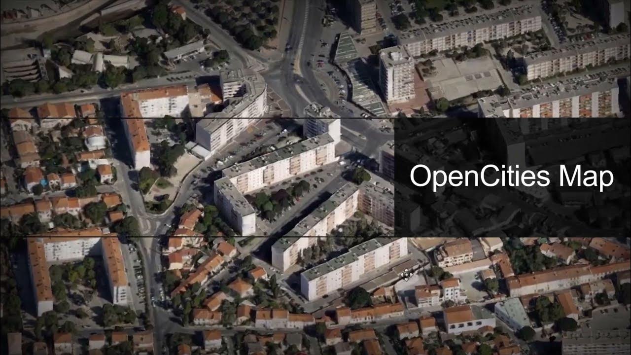
OpenCities Map
Desktop GIS and Mapping Software

ซอฟต์แวร์ด้านภูมิสารสนเทศ (Geospatial Software) ที่ถูกออกแบบมาเพื่อสร้าง ออกแบบ บริหารจัดการ วิเคราะห์ และแสดงข้อมูลทางภูมิศาสตร์ โดยข้อมูลทางภูมิศาสตร์นั้นหมายถึงข้อมูลที่อ้างอิงถึงตำแหน่งบนพื้นผิวโลก เช่น พิกัดทางภูมิศาสตร์ (Latitude, Longitude) หรือที่อยู่ เป็นต้น โดย OpenCities Map เป็นซอฟต์แวร์ด้านภูมิสารสนเทศ ที่เน้นในการสร้าง Digital Cities เพื่อพัฒนาต่อยอดสู่การเป็น Smart City หรือเมืองอัจฉริยะ
OpenCities Map ถูกพัฒนาต่อยอดมาจาก MicroStation โดยมีประสิทธิภาพในการบูรณาการงานเอกสาร และงานออกแบบต่างๆ ที่เกี่ยวข้องกับการดำเนินงาน เข้ากับระบบแผนที่ ทั้งแผนที่รูปแบบ 2 มิติ และ 3 มิติ อีกทั้งยังสามารถเชื่อมต่อกับระบบฐานข้อมูลทางภูมิศาสตร์ (Spatial Database) ต่างๆ ที่ได้รับความนิยมใช้งานกันอย่างแพร่หลายได้อย่างง่ายดาย เช่น Oracle Spatial, SQL Server Spatial, PostgreSQL (PostGIS) และ Esri (FGBD, ArcGIS Server และ Online) เป็นต้น
OpenCities Map เหมาะกับใคร
- Urban Designers
- Urban Planners
- Architects
- Civil Engineers
- Governments
โปรแกรม OpenCities Map มีให้เลือกใช้งาน 3 ระดับที่มีฟังก์ชั่นการทำงานแตกต่างกันไป ตามความต้องการของผู้ใช้งาน ได้แก่
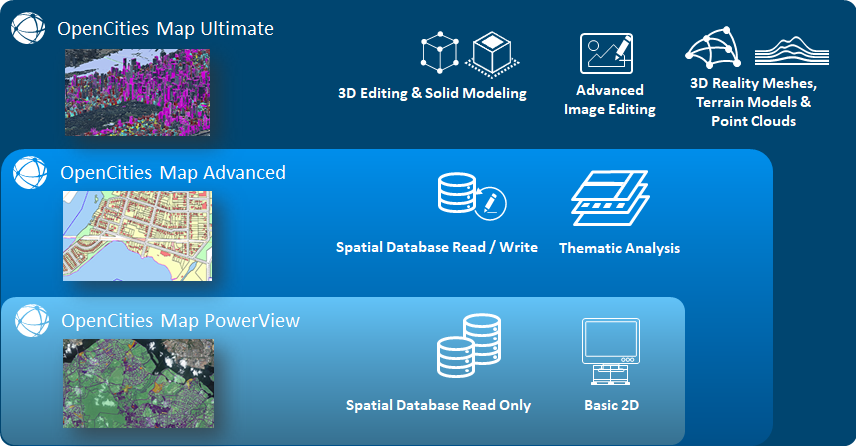
OpenCities Map PowerView
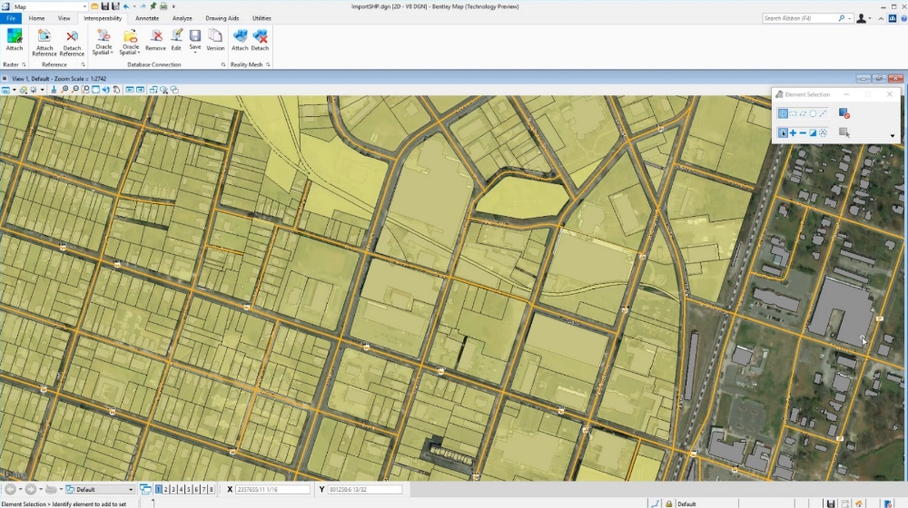
Desktop ซอฟต์แวร์ระดับเริ่มต้นของกลุ่ม OpenCities Map เหมาะสำหรับงานพื้นฐานที่ไม่ต้องการฟังก์ชั่นการทำงานที่ซับซ้อนเน้นสร้าง, ดู, แก้ไข และนำเสนอข้อมูลทางภูมิศาสตร์รูปแบบ 2D ในขั้นเบื้องต้น เช่น การเพิ่มจุด (Point) เส้น (Line) หรือพื้นที่ (Polygon) เป็นต้น รองรับการทำงานร่วมกับ CAD สามารถแปลงข้อมูล CAD ให้กลายเป็นข้อมูลภายในแผนที่ได้ โดยยังคงความถูกต้องไว้ตามมาตรฐานเดิม เชื่อมต่อกับระบบฐานข้อมูลทางภูมิศาสตร์ (Spatial Database) ได้แบบ Read-Only
SYSTEM REQUIREMENTS
| Minimum | Windows 8.1, 10, Server 2012 R2 (64 bit), or Server 2016 (64 bit); Citrix XenApp 7.15 64 bit for virtualized environments, Intel or AMD processor 1.0 GHz or greater, 4 GB memory, 25 GB storage |
| Recommended | 16 GB memory, up to 40 GB storage for companion features and applications |
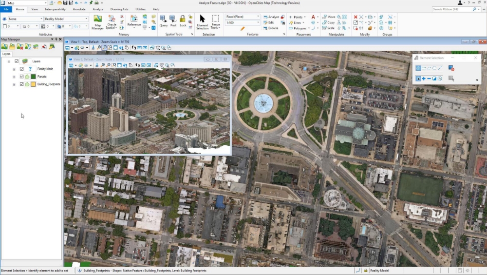
OpenCities Map Advanced
Desktop software ที่พัฒนาขึ้นเพื่อขยายขีดความสามารถในการทำแผนที่จาก OpenCities Map PowerView เน้นการวิเคราะห์ข้อมูลโดยสามารถทำงานร่วมกับซอฟต์แวร์อื่นๆ ได้อย่างสะดวก เช่น AutoCAD, MicroStation เป็นต้น เพื่อเพิ่มประสิทธิภาพในการทำงานเหมาะสำหรับงานสร้างแผนที่ที่ต้องการความแม่นยำสูงและความละเอียดในการวิเคราะห์ข้อมูลเชิงลึก เช่น ออกแบบแผนที่เพื่อการวางแผนโครงสร้างพื้นฐาน ออกแบบแผนที่เพื่อการจัดการทรัพยากรธรรมชาติ และออกแบบแผนที่เพื่อใช้ในงานด้านวิศวกรรม เป็นต้น ทำงานร่วมกับข้อมูล 2D 3D และสามารถนำเข้า Reality Meshes ที่สร้างจาก iTwinCapture Modeler มาแสดงผลเพื่อ Snap, Measure, Render, และ Interact ได้ และเชื่อมต่อกับระบบฐานข้อมูลทางภูมิศาสตร์ (Spatial Database) แบบสามารถเรียกดูและแก้ไขได้
SYSTEM REQUIREMENTS
| Minimum | Windows 11 or 10 (64 bit), Windows 11 or 10 (21H2), Windows Server 2019, Windows Server 2016 (64 bit) Intel® or AMD® Processor 1.0 GHz or greater, 4 GB memory |
| Recommended | 16 GB memory |
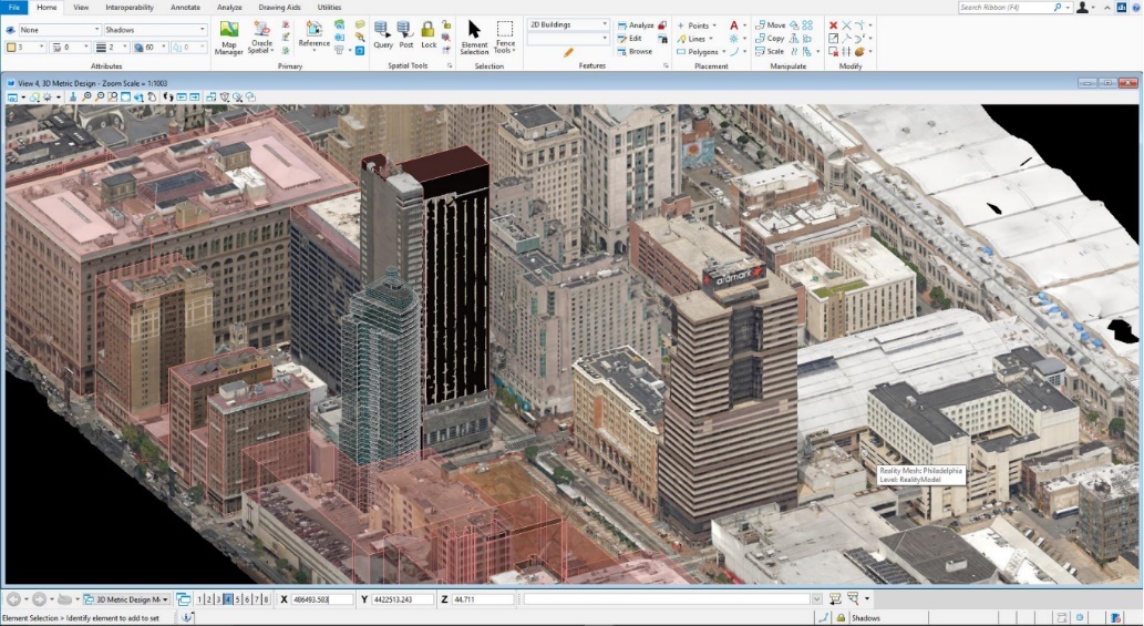
OpenCities Map Ultimate
Desktop ซอฟต์แวร์ที่ขยายขีดความสามารถจาก OpenCities Map PowerView และ OpenCities Map Advanced ทำให้ OpenCities Map Ultimate เป็นโปรแกรมที่ Full power สำหรับงานทางด้านภูมิสารสนเทศมากที่สุดในบรรดา OpenCities Map สามารถนำเข้าและแก้ไขข้อมูล 3 มิติได้ มีเครื่องมือสำหรับการทำงานกับ Solid Modeling โดยเฉพาะ จัดการกับข้อมูลขนาดใหญ่ได้อย่างมีประสิทธิภาพโดยสามารถทำงานร่วมกับ Reality Data ได้โดยตรง เช่น Point Cloud, Raster, STM และ Reality Meshes ทั้งยังสามารถ จำแนกประเภท Point Cloud ได้ ซึ่งจะช่วยให้วิเคราะห์ข้อมูลได้อย่างถูกต้องครอบคลุม และแม่นยำสูง
SYSTEM REQUIREMENTS
| Minimum | Windows 11 (64-bit), Windows 10 (64-bit), Windows Server 2022, or Windows Server 2019, Intel or AMD processor 1.0 GHz or greater, 4 GB memory, 25 GB disk space |
| Recommended | 16 GB memory, up to 40 GB disk space |
Youtube: OpenCities Map Ultimate
Video
Capabilities
- Capture existing context in 3D
- Conduct 2D and 3D spatial analysis
- Develop custom GIS applications
- Incorporate data in native Esri formats
- Incorporate geospatial data from spatial databases
- Maintain 3D city models
- Manage geospatial information
- Manage land information and records
- Model geospatial objects
- Produce animations and renderings
- Produce cartographic maps
Capture existing context in 3D
Integrate engineering data, survey data, point clouds, and digital imagery to create and update highly accurate 3D city information models and databases. Automatically create 3D reality meshes of cities.
x
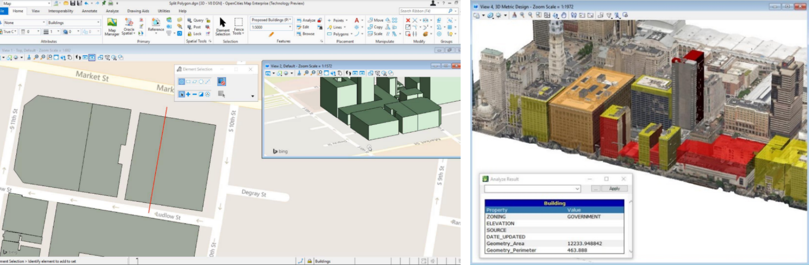
Conduct 2D and 3D spatial analysis
Analyze data with tools for buffering, overlays, thematic maps, and 3D clash detection. Perform shadow and solar analysis.
x
Develop custom GIS applications
Create your own custom GIS application, tailored to your needs. The software is designed with a remarkable degree of flexibility and has an extensive API supporting custom development using C/C++, C#, .NET and other modern programming languages. The kit includes extensive documentation and samples.
x
Incorporate data in native Esri formats
Improve interoperability by incorporating data in native Esri formats. Import, export, or reference Esri SHP files. Connect and perform direct transactions with File Geodatabase.
x
Incorporate geospatial data from spatial databases
View and import Web Feature Service (WFS) data directly. Access, update, and manage spatial data stored in Oracle Spatial, Microsoft SQL Server, and Esri File Geodatabase in a seamless and intuitive way.
x
Maintain 3D city models
Edit, maintain, and manage your 3D city model data including unstructured and structured data such as geospatial, architectural, and engineering designs, point clouds, and reality meshes. Seamlessly integrate with enterprise spatial databases such as Oracle Spatial and SQL Server Spatial.
x
Manage geospatial information
Overcome the challenge of managing, collaborating on, and sharing geospatial and related data in a federated environment by combining map-based interface with project, document, and workflow management capabilities. Navigate and retrieve content based on specific locations in a controlled and secure way.
x
Manage land information and records
Optimize your land information management with federated geospatial data management, open spatial databases, and 2D and 3D parcel management for land registration, information, and tax purposes.
x
Model geospatial objects
Create intelligent geospatial objects with advanced 2D and 3D design productivity innovations using interactive snapping tools. Use tools for dimensioning, annotation, raster display, printing, publishing, and much more.
x
Produce animations and renderings
Secure stakeholder buy-in by producing realistic movies and simulations from design, construction, and operational models. Choose from keyframe and time-based animation. Get the results you want, faster, using live on-screen animation previews and distributed network processing. Create lifelike visualizations and access online and delivered libraries of physically correct materials, lighting, and rich photorealistic content.
x
Produce cartographic maps
Author and publish high quality, accurate cartographic and thematic maps. Create multiple pages in map books with borders and populated fields, dynamic labeling and text placement, grid and graticule generation, drop shadows, halo effects, and high fidelity printing and publishing.
x


